Property Crime per Capita in Thrall
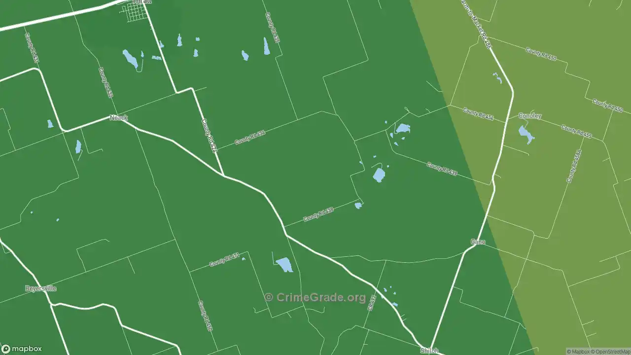
Property crime covers theft, burglary, vehicle theft, and arson, offenses against belongings rather than people. The map below shows the property crime rate per 1,000 Thrall residents.

Property crime covers theft, burglary, vehicle theft, and arson, offenses against belongings rather than people. The map below shows the property crime rate per 1,000 Thrall residents.
$169,441
In 2025, property crime will cost $173 per household.
On the map, green marks the parts of Thrall with the least property crime and red marks the most, weighted by the type and severity of each offense. Property crime is the most common category of crime, so these maps track closely with where stores, parking, and daytime foot traffic sit. The Interpreting the Crime Maps section below explains why busy commercial blocks can look worse than the neighborhoods around them.
The B+ grade reflects how often theft, burglary, vehicle theft, and arson happen in Thrall against the average US city, where the rate is lower than the norm. Thrall sits in the 71st percentile for property-crime safety, ahead of 71% of cities and behind 29%. The grade covers only Thrall’s official city boundaries. See the table below for nearby cities.
The property crime rate in Thrall is 8.877 per 1,000 residents in a typical year. Residents generally point to the southwest part of the city as the safest for their belongings. Your odds of a property-crime loss range from 1 in 82 in the east neighborhoods to 1 in 137 in the southwest.
Counting total incidents instead of per-capita rates, the east parts of Thrall, TX report the most property crime, about 5 cases per year. The southwest part reports the fewest, around 0 per year.
Property crime in Thrall is projected to cost $169,441 in 2025, about $65 per resident and $173 per household. That equals 0.2% of the median household income. All of it is measurable loss: replaced vehicles, repaired break-ins, stolen goods, and the policing and courts that respond.
Because property crime leaves a repair bill rather than a lasting injury, these tangible costs make up its full economic toll. They split into:
| Thrall, TX: | $65 |
|---|---|
| Cuero, TX: | $448 |
| Lavon, TX: | $26 |
| Texas: | $164 |
| USA: | $136 |
Property crime costs $65 per resident each year in Thrall, which is $71 less than the national average and $100 less than Texas’s state average. The comparison below uses cities similar to Thrall:
The table below breaks the property-crime total into its four offenses for Thrall, with the projected cost per resident.
Crime |
Cost to Thrall |
Cost per Thrall Resident |
|---|---|---|
Vehicle Theft |
$44,795 |
$17 |
Burglary |
$38,017 |
$15 |
Theft |
$82,687 |
$32 |
Arson |
$3,942 |
$2 |
Total Cost of Property Crime |
$169,441 |
$65 |
Property crime carries no pain-and-suffering figure in this model. Its cost is the replacement and repair value of what was taken or damaged, plus the policing, courts, and lost offender productivity that follow. Stolen and damaged property has a market price, which is why this total is easier to pin down than the human cost of violent crime in Thrall, TX.
All Cost of Crime figures come from scholarly research on the cost of crime. Read more about our methodology here.
Property crime rates are measured per resident, so places where shoppers and commuters outnumber residents read high. Stores are where shoplifting, theft, and vehicle break-ins happen, yet almost nobody lives there, so the per-capita rate climbs. How strongly this shows on the map depends on retail density; the northwest part of the city has more retail establishments. A red commercial strip does not mean the homes nearby are unsafe.
Parking lots and transit stops follow the same pattern: heavy daytime traffic, few residents, so per-capita property crime reads high. To judge a residential block, weigh both the per-capita rate and the total number of incidents, and note what sits nearby.
The interactive maps load faster on a strong connection. Compare high speed internet in Thrall, TX at ISP Reports.
The table below shows which non-violent crimes are used to calculate the Crime Grade above. All property crime rates are shown as the number of crimes per 1,000 Thrall residents in a standard year.
Crime Type |
Crime Rate |
|---|---|
Theft |
6.105 |
Vehicle Theft |
1.106 |
Burglary |
1.603 |
Arson |
0.0624 |
Total Property Crime |
8.877 (B+) |
Compared to surrounding cities, the rate of property crime in Thrall is lower. The table below shows Crime Grades for cities close to Thrall.
Nearby City | Overall Crime Grade | Violent Crime Grade | Property Crime Grade |
|---|---|---|---|
A- | B+ | B+ | |
B- | C- | B+ | |
B+ | B- | B- | |
B | C+ | B- | |
B- | B+ | B- | |
C- | C- | D+ | |
B+ | C+ | B- | |
A- | B- | A- | |
A- | C+ | B+ | |
D | B- | D- |
Thrall is lower versus other cities of the same size for property crime. The table below compares crime in cities with comparable overall population in the city‘s boundaries.
Similar City | Overall Crime Grade | Violent Crime Grade | Property Crime Grade |
|---|---|---|---|
C | D+ | D+ | |
C- | C- | C- | |
B+ | C+ | C+ | |
D- | D+ | D+ | |
B+ | B | B | |
B | C | C | |
B | D+ | D+ | |
C- | D+ | D+ | |
C+ | C- | C- | |
D- | C | C |
Considering only the property crime rate, Thrall is safer than the Texas state average and safer than the national average.
CrimeGrade.org provides highly detailed and accurate crime data, used by insurance companies, home security firms, and other industries. Our data is available for licensing—learn more about our USA crime data and licensing.
Our proprietary data is available for download by zip code or by state in a CSV Flat File. Please visit our download page for pricing and terms.
Download CSV
A crime occurs on average every 8 days 11 hours in Thrall. Want to protect your home?
Home Security Companies in Thrall, TX
All maps and statistics above are projections, not certainties, and provided without guarantee free of charge. Verify all info before making any decisions based on the data.