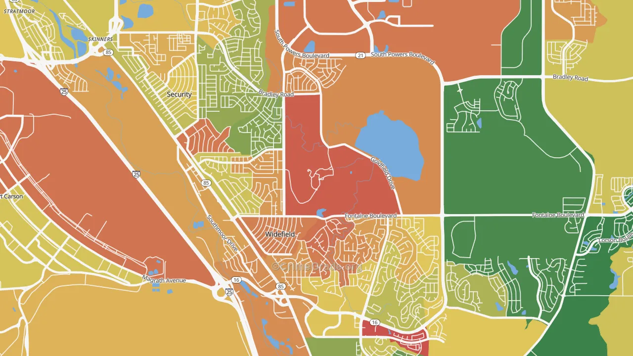
Widefield, Security-Widefield, CO Property Crime Rates and Maps
Widefield is a neighborhood of 15,700 residents in Security-Widefield · Updated November 2026
How common is property crime in Widefield?
Property crime is high in Widefield: a B-, with more property crime than the neighborhoods where 75% of Americans live. Theft makes up 52% of it. Burglary, the crime most likely to reach into a home, grades B+, and vehicle theft grades B-. Security-Widefield as a whole grades B- for property crime.
B-
Property crime CrimeGrade™
Safety score 586 of 1,000More property crime than most US neighborhoodsi What this means
25% of Americans live in neighborhoods with more property crime than Widefield as a whole, and 75% in neighborhoods with less. The typical US neighborhood has a property crime safety score of 823, a CrimeGrade™ of A-. Widefield scores 586.
Crime is concentrated in a small share of places, so most neighborhoods score high on the 0 to 1,000 scale. That is why a score in the 800s can still mean more property crime than most US neighborhoods.
How to read the map: each area's color compares its property crime with the homes, parked cars and people there, on one national scale, from green for the least to red for the most. Each area gets its own color, so a busy shopping center can show red while the homes beside it stay green. The interactive maps load faster on a strong connection. Compare high speed internet in Widefield, Security-Widefield, CO at ISP Reports.
Who this page is for: homeowners and renters in Widefield in Security-Widefield, and anyone thinking about buying or renting a home there.
Business and enterprise customers: this free map shows neighborhood areas. CrimeGrade™ business reports map crime at about 66-meter detail and estimate it for one address and type of business. See business reports
How Widefield compares within Security-Widefield
Low property crime is the norm across Widefield: 65% of residents live in areas graded A or B, and the rest in areas graded C. Property crime grades across Widefield run from B+ to C-.
65%35%
A or B 65%C 35%
Share of residents, by the property crime CrimeGrade™ of the area they live in.
Widefield has less property crime than 1 of the 2 neighborhoods in Security-Widefield. It covers much of the Widefield area.
Property crime rates and types in Widefield
CrimeGrade™ estimates Widefield has about 25 reported property crimes a year for every 1,000 residents, 5% more than the US as a whole and close to Security-Widefield as a whole.
All property crime
Burglary
Vehicle theft
Reported crimes a year, per 1,000 residents. Property crime here includes vandalism, which the FBI's property crime rate leaves out.
Theft is the most common property crime in Widefield, about 52% of the total, followed by vandalism and vehicle theft.
Each CrimeGrade™ here compares a property crime with what it affects: homes for burglary and arson, parked cars for vehicle theft, people and parking for theft, homes and businesses for vandalism. Rates count crimes per 1,000 residents.
Select a crime's name to see its map above. CrimeGrade™ business reports map each crime at about 66-meter detail.
Property crime in Widefield and nearby neighborhoods
Widefield has less property crime than 8 of its 10 nearest neighborhoods; only Southwest Colorado Springs and Stratmoor Hills have less.
Nearest first, with each place's distance from Widefield. Beside each property crime CrimeGrade™ is its safety score, from 0 to 1,000 (higher is safer).
Compared with neighborhoods of similar size and density, Widefield has more property crime than 52% of them.
Walkability, night lighting and shops in Widefield
Among the traits that tend to go with property crime, two set Widefield apart: it has a Walk Grade of D- (7 of 100) on BestNeighborhood, against 21 for the US as a whole, and 3.5 stores and restaurants for every 1,000 residents, against 10.5 nationally. Places like that tend to report less theft, yet theft runs higher here than that would suggest.
Walk GradeBestNeighborhood's grade for getting through daily life on foot, traced along real walking routes to shops, schools and parks. Walkable places tend to report more theft. 96% of residents here live in car-dependent areas.D- (7 of 100)US: 21Lower than for 96% of residents of US city neighborhoods
Lit at nightSatellite images show which neighborhoods are lit at night, a sign of busy streets and businesses. Brightly lit places tend to report more theft and vandalism.97% where people liveUS: 78%Lower than for 95% of residents of US city neighborhoods
Stores and restaurantsShops and restaurants draw crowds and parked cars. Places with many stores tend to report more theft and car theft.3.5 per 1,000 residentsUS: 10.5Lower than for 89% of residents of US city neighborhoods
Show all 4
Residents in dense blocksBlocks of 10,000 or more people per square mile. Dense neighborhoods tend to report more car theft.15% of residentsUS: 24%Lower than for 86% of residents of US city neighborhoods
These traits tend to go with more or less crime; none of them causes it on its own. Sources: Census job counts and housing figures, OpenStreetMap and Overture business listings, CrimeGrade™ parking estimates, NASA night-light imagery, US Forest Service tree cover, EPA transit data and BestNeighborhood's Walk Grade.
What property crime costs Widefield
Property crime costs Widefield about $3.0 million a year, or $190 per resident and about $548 per household: the value of what is stolen or damaged, plus the police, courts and prisons that respond.
Cost of property crime per resident, per year
How CrimeGrade™ works
The property crime CrimeGrade™ covers burglary, theft, car theft, arson and vandalism, from A+ for the least crime to F for the most, on one scale for the whole country.
It weighs each property crime against what it affects: homes for burglary and arson, parked cars for car theft, and the people and parking around stores for theft.
The rates on this page count crimes for every 1,000 people who live here, the way police departments report them.
Comparisons with US neighborhoods use the Census Bureau's block groups, small areas of about 1,400 residents, and count the people who live in each. The figures count crimes reported to police; many crimes, shoplifting above all, never are. Behind the grades, CrimeGrade™ tested 21,607 factors from 125 data families. For business owners, paid CrimeGrade™ location reports estimate crime at a single address for each type of business.
Where the numbers come from
Crime reports that police departments file with the FBI
State crime records and city crime data, where they are published
Published research on what crime costs victims and communities
These are estimates of reported crime for whole areas, not a record of what happened on any one street. CrimeGrade™ updates them once a year and provides them free and without guarantee. Check local sources before you rely on them for a decision.