Cost of Crime™ for Indian Springs, The Woodlands, TX
$2.92 million
In 2025, crime will cost $1,775 per household.
More cost data
Put this on your site: embed the map, grade card or badge.
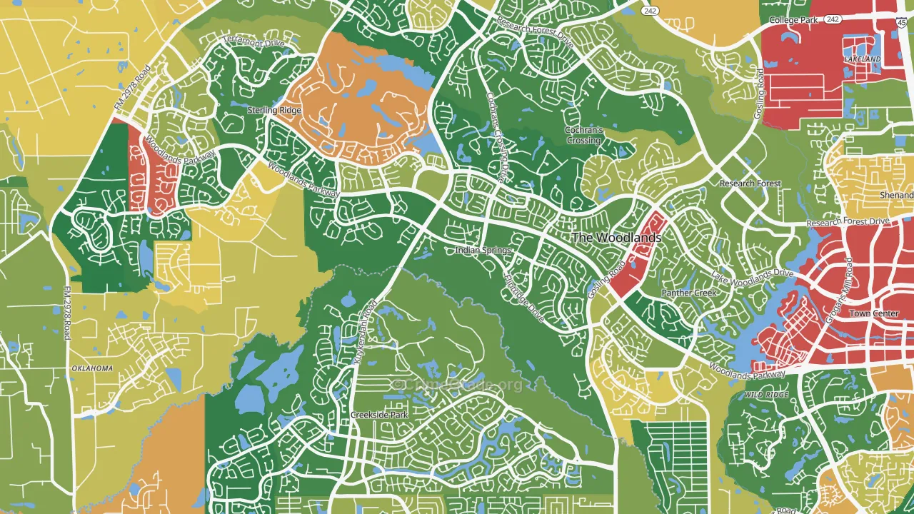
On the map, green marks the parts of Indian Springs with the least crime overall and red marks the most. Each area is weighted by the type and severity of every offense, so a place with rare but serious violent crime can grade differently from one with frequent petty theft. The Interpreting the Crime Maps section below explains how to read the colors.
Is Indian Springs, The Woodlands, TX Safe?
The A- overall grade blends the violent, property, and other grades shown above into one measure, set against the average US neighborhood, where Indian Springs’s combined rate is lower than the norm. Indian Springs sits in the 83rd percentile, ahead of 83% of neighborhoods and behind 17%. The grade covers only Indian Springs’s official city boundaries. See the table below for nearby neighborhoods.
The overall crime rate in Indian Springs is 22.39 per 1,000 residents in a typical year. Residents generally consider the southeast part of the neighborhood the safest. Your chance of being a victim ranges from 1 in 43 in the northwest areas to 1 in 49 in the southeast.
Counting total incidents instead of per-capita rates, the southeast parts of Indian Springs, The Woodlands, TX report the most crime, about 32 cases per year. The southwest part reports the fewest, around 0 per year.
The Cost of Crime™ in Indian Springs, The Woodlands, TX
Across all crime types, the projected cost of crime in Indian Springs for 2025 is $2,924,989, about $559 per resident and $1,775 per household. That equals 0.6% of the median household income.
These figures cover tangible costs, which include:
- Criminal justice system costs (law enforcement, courts, and imprisonment): 45.6%
- Direct costs to victims (damaged property, medical expenses, and lost wages): 42.7%
- Lost economic contribution from offenders (time in prison or repeat offenses): 11.7%
How Much Does Crime Cost in Indian Springs Compared to Other Neighborhoods?
| Indian Springs, The Woodlands, TX: |
$559
|
| Downtown Houston, Houston, TX: |
$1317
|
| Villages of Westcreek, San Ant: |
$194
|
| Texas: |
$555
|
| USA: |
$464
|
The overall cost of crime per resident in Indian Springs is $559 per year, which is $95 more than the national average and $4 more than The Woodlands’s city average. The comparison below uses neighborhoods similar to Indian Springs:
- In Downtown Houston, Houston, TX, crime costs $1,317 per person, which is $758 more than in Indian Springs.
- In Villages of Westcreek, San Ant, crime costs $194 per person, which is $365 less than in Indian Springs
2025 Projected Cost by Type of Crime
The table below shows the total cost of crime to the residents of Indian Springs for the year 2025 along with the projected cost per resident.
Crime |
Cost to Indian Springs |
Cost per Indian Springs Resident |
Murder |
$1.45 million |
$277 |
Rape/Sexual Assault |
$168,624 |
$32 |
Robbery |
$67,765 |
$13 |
Assault |
$301,497 |
$58 |
Kidnapping |
$26,550 |
$5 |
Vehicle Theft |
$336,097 |
$64 |
Burglary |
$110,215 |
$21 |
Theft |
$79,631 |
$15 |
Arson |
$13,503 |
$3 |
Vandalism |
$139,169 |
$27 |
Animal Cruelty |
$5,114 |
$1 |
Drug Crimes |
$219,933 |
$42 |
Identity Theft |
$6,201 |
$1 |
Total Cost of Crime |
$2,924,989 |
$559 |
The Intangible Cost of Crime in Indian Springs, The Woodlands, TX
The totals above count tangible costs only. Violent crime also carries a human cost, the pain and trauma borne by victims and their families, which research-based methods estimate so it can be compared across places.
That intangible cost in Indian Springs totals $10,509,207 ($2,009 per resident), and all of it comes from violent crime rather than property loss. Added to the tangible costs, the full estimate reaches $13,434,195 ($2,568 per resident).
All Cost of Crime figures come from scholarly research on the cost of crime. Read more about our methodology here.
Interpreting the Crime Maps
Crime rates on the map are measured per resident, so areas with heavy visitor traffic can read high because crime follows crowds, even where few people live. The north part of the neighborhood holds more retail establishments, which lifts recorded crime around those blocks. A red area does not always mean the neighborhood is unsafe for residents.
Airports, parks, and transit hubs create the same effect. Major airports draw large crowds with few residents nearby, so they read as high-crime spots. Parks and recreational areas, of which Indian Springs has 1, do the same, and of Indian Springs’s 5,231 residents few live beside them. Before assuming an area is unsafe, weigh both the per-capita rate and the total number of incidents, and note what sits nearby.
The interactive maps load faster on a strong connection. Compare high speed internet in Indian Springs, The Woodlands, TX at ISP Reports.
Indian Springs Crime Breakdown
The tables below show which crimes are used to calculate the Crime Grades above. All crime rates are shown as the number of crimes per 1,000 Indian Springs residents in a standard year.
Violent Crime Rates
Crime Type |
Crime Rate |
Assault |
2.007 |
Robbery |
0.4118 |
Rape |
0.5316 |
Murder |
0.1476 |
Total Violent Crime |
3.098 (B+) |
|
|
Property Crime Rates
Crime Type |
Crime Rate |
Theft |
2.939 |
Vehicle Theft |
4.149 |
Burglary |
2.323 |
Arson |
0.1069 |
Total Property Crime |
9.518 (A+) |
|
|
Other Crime Rates
Crime Type |
Crime Rate |
Kidnapping |
0.0837 |
Drug Crimes |
5.684 |
Vandalism |
3.724 |
Identity Theft |
0.1532 |
Animal Cruelty |
0.1322 |
Total "Other" Rate |
9.777 (C+) |
Crime Maps and Rates for Nearby Neighborhoods
Compared to surrounding neighborhoods, the rate of crime in Indian Springs is lower. The table below shows Crime Grades for neighborhoods close to Indian Springs.
Nearby Neighborhood | Overall Crime Grade | Violent Crime Grade | Property Crime Grade |
|---|
| A+ | A- | A+ |
| A+ | A+ | A+ |
| C+ | B | C |
| B+ | B+ | A- |
| A- | A- | A |
| C+ | B- | B- |
| B- | B- | B+ |
| A | A | A |
| A- | B+ | A+ |
| A- | A- | B+ |
Crime Maps and Rates for Neighborhood with Similar Populations
Indian Springs is lower versus other neighborhoods of the same size for crime. The table below compares crime in neighborhoods with comparable overall population in the neighborhood‘s boundaries.
Similar Neighborhood | Overall Crime Grade | Violent Crime Grade | Property Crime Grade |
|---|
| C | B+ | B+ |
| C- | D+ | D+ |
| B | B- | B- |
| C+ | A | A |
| F | F | F |
| B | C | C |
| C | D+ | D+ |
| A | A | A |
| D | D- | D- |
| F | D- | D- |
Considering only the crime rate, Indian Springs is safer than the Texas state average and safer than the national average.
Safety and school performance are separate topics, but both shape moving decisions. Using SchoolGrade data, schools in Indian Springs, The Woodlands, TX average SchoolGrade of A, with 65% actual proficiency versus 57% projected; overall, schools greatly exceed expectations. See Indian Springs schools on SchoolGrade
About the Data
CrimeGrade.org provides highly detailed and accurate crime data, used by insurance companies, home security firms, and other industries. Our data is available for licensing—learn more about our USA crime data and licensing.
Crime By Zip Code Download
Our proprietary data is available for download by zip code or by state in a CSV Flat File. Please visit our download page for pricing and terms.
Download CSV
Home Security
A crime occurs on average every 3 days 2 hours in Indian Springs. Want to protect your home?
Home Security Companies in Indian Springs, The Woodlands, TX
All maps and statistics above are projections, not certainties, and provided without guarantee free of charge. Verify all info before making any decisions based on the data.